
My wife and I have our differences over sunrises. My wife assumes that a decent sunrise is a predictable event, while I know from practice that whatever the forecast says, there is no true way of evaluating a sunset other than looking out the door well before the sun has risen. Even then I have driven miles in the dark only to find cloud has rolled in obscuring the sun.
This in turn creates conflicts, since she expects at least 48-hour notice for any photography trips, while I generally don't always know whether it's worth going out till the morning in question.
The other problem is she frequently asks why, if I am going out, why she could not come. Apart from the fact, I am an unsociable bugger when in photographic mode, sunrises by their very nature are early in the morning. I find I can get out of the house in about 15 minutes, my wife's record is about an hour.
However, sunrises won't wait, and typically you want to be there an hour before the sun rises above the horizon. To be honest, I'm not great about this either. A combination of laziness, inertia, lack of confidence can stymie your efforts to get out the door at an ungodly hour, or set off too late and then kick yourself as the sunrise of sunrises occurs while you are still driving to your destination. (alternatively, you can do what I did once and arrive 2 hours too early and have to kick your heals in pitch blackness)
I bring this up because I did actually manage to get out for the sunrise today.
I have been planning this trip for a few weeks. My target was Bennerley viaduct near Ilkeston, about a 20-minute drive and because we are basically still in winter, it meant that I could get going at a reasonable time.
This blog post is not about sunrises however but Bennerley viaduct and the possibilities to the photographer
The Iron Giant
Bennerly viaduct is a disused railway viaduct spanning the Erewash Valley between Awsworth (Nottinghamshire) and Ilkeston (Derbyshire) in central England. It was built in 1877 but closed to rail traffic in 1968.
Unlike most viaducts, it is built from a lattice of ironwork, making it appear as a giant spider web. The reason for this is it is built over an area of coal mining subsidence, so need greater flexibility than a brick built structure could offer.
In truth, it is amazing it has survived at all. It managed to survive Zeppelin attacks in the 1st world war, and the bombing of the 2nd, together with the more serious government attacks via the Beeching cuts in the 1960's. The only reason it survived then was due to its construction methods, it was deemed too expensive to demolish and for many years lay isolated. As such, it is almost the only surviving example of this sort of bridge and certainly the most accessible.
That is until a concerted effort was made by local people to restore the viaduct and convert it into a cycling/walking path. The Friends of Bennerley Viaduct was set up to fundraise and manage this.
When I first visited in 3 years ago, the bridge itself was still off limits, and access was not clear. However, just this month (Jan 2022) it was announced that the bridge was open to visitors. As a result the 1452 feet long viaduct rising 60 feet above the Erewash river is now open to all and I felt it was time to investigate the site more fully.
Perils in the dark
To plan my visit, I checked the photo ephemeris site to check which direction the sun would appear. Then I had to work out from Google maps whether I could get to where I wanted to go and how.
One of the challenges of visiting a new site for a sunrise is that you
will be stumbling around in the dark with no real idea how to get where
you want to g It appeared that there was an area of waste ground behind the site that would provide the best angle to catch the sun, but although google maps is fantastic it would not tell me whether the pathway shown was open or how to get to it. I would just have to hope for the best.
When I woke up, and looked outside my window, the sky was clear. While this was good, I was hoping for a bit of cloud, but part-time snappers cannot be choosers, so creeping out of the house, and into the car, it was a quick jaunt up the M1 and I arrived at least an hour before sunrise.
As I said, I had no idea of how I was going to get to the viaduct and first signs were not hopeful, facing a low gate with a danger "construction traffic" on it. Assuming that this was a hangover from the reconstruction work I climbed under it and set along a wide paved path that I hoped would take me to my target (It was only when I got back to the car in daylight, I found a full functional path next to it)
The path to the viaduct itself was easy, despite the dark. The next challenge was that I had to cross the river Erewash to get to waste ground on the other side. On Google Maps it seemed to show a bridge, however what it did not show was a substantial gate across it. Initially, it looked like I would have to clamber over it, until I noticed that a large amount of the wire netting had been removed, allowing me to easily duck under it.
Why here?
So why did I want to photograph this bridge? Well, firstly, I love a new location and the new access offered a number of possibilities. Sitting in the middle of the Erewash valley with no buildings nearby, it allows you to explore the angles with little compromise.
Also being a lattice structure, it allows the light through. My hope was that I could photograph the sun through the lattice as it rose
As it was, I spent a period of time trying out different angles. One of the things I loved was the way it seemed to tail off into the distance, creating a Lacey ribbon in the sky.
One thing I quickly realised was that the sun through lattice effect was going to be challenging because the sun would need to rise above some low hills, meaning I needed to be higher. A drone would be perfect in this situation, and I am sure that this will be a major destination for drone photographers in the future. However, not owning one I had to do something else
 |
| Viaduct in the blue hour |


As the light grew, I noticed a pedestrian walkway over the nearby rail line, which would give me some needed height. I decided therefore to try there. The next challenge was to find it in the dark, which I eventually managed. This gave me a higher angle, so I could capture the sun well before ground level.
One of the things I tried was to capture the silhouettes of joggers and cyclists on the bridge to provide scale. Even this early there was a lot of traffic, which is a testament to the success of the project.

 |
| An early morning walker crosses the bridge |

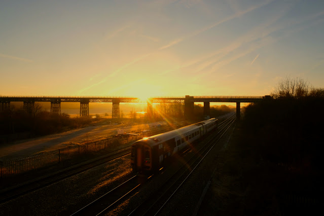 | |||||
| Yes, its a train. Get over it |

One advantage, being up high, was that I now had more time to explore the viaduct, so I worked my way down and tried to find the entrance. I later found that I could have continued over the walkway and followed the canal to the entrance ramp, however instead I headed across the waste ground to find the East path.
From the viaduct you are afforded fine views of the Erewash valley, and it would be great to come back on a misty day
 |
| View from a viaduct |
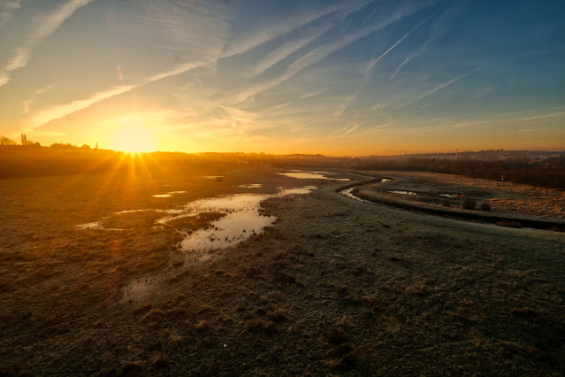 |
| The Erewash valley |
Conclusion
One of the joys of photography is finding new locations. Bennerley offers a lot both in the structure itself, the location and historical perspective.
It will definitely be on my photography location list and I recommend anyone in the area to have a look
Being in the open affords good access for landscape photographers and sunrises and sunsets shots should be possible, although check the sun angles before hand.
Information
Bennerley viaduct is located between the Erewash Canal and the disused Nottingham canal
Parking can be had at the Newton Lane Car Park, Awsworth Road, Ilkeston
To access the area underneath the bridge, there is a path from Awsworth road, where you can also access the railway crossing
Access paths are pretty good, with only a bit of scrambling to reach the Northside of the bridge.
